Science Overview
The Earth’s outer shell, the crust, is composed of rigid tectonic plates that stick and slip past one another (Figure 1). Earthquakes, which usually occur at the boundaries between tectonic plates, release seismic waves. By installing earthquake-monitoring stations we are able to record ground motions from seismic waves. These records are known as seismograms (Figure 2). The seismograms contain information about the structure of the Earth along the path that the waves traveled.
Three types of boundaries exist for tectonic plates: divergent, transform, and convergent. Imagine tectonic plates like blocks; there are only a few ways these blocks can move relative to one another (Figure 3). If the plates slide past one another, this is called a transform boundary. Plates that move toward each other form convergent boundaries. Lastly, a divergent boundary is when plates move apart from one another.
Notice that a “gaps” forms at a divergent boundary as the plates continue to separate. When tectonic plates move apart from one another, magma fills the gaps and creates new crust. Since the surface area of the Earth is unchanging, there must also be a way to get rid of crust. At convergent boundaries, portions of crust are subducted (go under another plate); this effectively removes portions of the crust from the surface of the Earth (Figure 4). Hence there is a balance between divergent boundaries creating crust and convergent boundaries removing it.
This balancing act of the Earth’s crust has been named the Wilson cycle (Figure 5). For our study (SPREE) we are interested in the beginning stages of the Wilson cycle, called continental rifting. The feature that we are studying is the Mid-Continent Rift. This is where the North American continent tried to split apart and create a divergent boundary. If continental rifts are successful, a new ocean will be formed (such as the Atlantic Ocean). The Mid-Continent Rift is considered a failed rift because it did not create an ocean.
The Mid-Continent Rift appears to have made it about as far as possible without succeeding, based on the large volume of magma (new crust) in the rift. Our study is attempting to figure out how and why the Mid-Continent Rift formed where it did, and why it failed after progressing into the late stages of continental rifting.
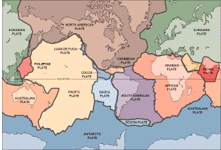
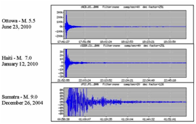
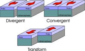
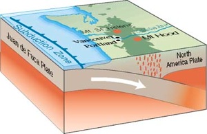
Figure 1: Major tectonic plates. Each different color represents a plate. (www.usgs.gov)
Figure 2: Examples of seismograms
Figure 3: Types of plate boundaries. Divergent plates move apart from one another. Convergent plates move toward each other. Transform boundaries are where plates slide past one another. (http://geology.csupomona.edu/drjessey/class/Gsc101/Plate.html)
Figure 4: Subduction of an oceanic plate at a convergent boundary (http://www.emporia.edu/earthsci/student/geller2/cascadia.html)
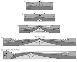
Figure 5: Schematic illustrations of the Wilson cycle, the fundamental geological processes controlling the evolution of the continents a-b) A continent rifts, such that the crust stretches, faults and subsides. c) Seafloor spreading begins, forming a new ocean basin. d) The ocean widens and is flanked by sedimented passive margins. e) Subduction of oceanic plate begins on one of the passive margins, closing the ocean basin (Stein & Wysession, 2003. An Introduction to Seismology, Earthquakes, and Earth Structure)