Title: Fabric in the crust and mantle across the Mid-Continent Rift
NSF award number:
EAR-0952345 ("SPREE") (2010-2014)
Collaborators
Andrew W. Frederiksen, Justin Revenaugh,
Oyekunle Ola,
Suzan van der Lee1, Emily Wolin1,
Trevor A. Bollmann1, Douglas A. Wiens3, Fiona A. Darbyshire5, Ghassan I.
Aleqabi3, Michael E. Wysession3, Seth Stein1, and Donna M.
Jurdy1
Summary:
The Superior Province
Rifting Earthscope Experiment (SPREE) was a two-and-a-half year project to
record distant earthquakes at seismic stations in Minnesota, Wisconsin, and
Ontario. This region straddles a major North American geological feature: the
1.1 billion-year-old Mid-Continent Rift (MCR). By analyzing earthquake recordings,
we obtain information on structures within the Earth's crust and mantle beneath
the instruments. We analyzed a type of earthquake wave that travelled through
the Earth's core and is called SKS. SKS waves have the useful property that,
upon emerging from the core, they are polarized in a predictable way. If the
recorded SKS waves do not match this
expected polarization, the polarization must have been modified by an oriented
fabric beneath the receiver: a consistent direction of alignment of crystals
within the rock. We measured the strength and orientation of this fabric from
SPREE data.
We found that although
the fabric orientation ("fast direction") is consistently SW-NE, the fabric
strength ("split time") varies considerably over the study area. The fabric is
fairly strong beneath the western rift branch, but weaker around Lake Superior.
The fabric is strong north of Lake Superior, except near Lake Nipigon and near
the eastern terminus of Lake Superior. The fabric likely results from a
combination of frozen fabric, from formation of the North American continent,
and deformation resulting from current motion of the North American plate. The
difference between Lake Superior and the western branch of the MCR suggests
that the effect of the rift on fabric was quite complex.
Location tags: Minnesota, Wisconsin,
Ontario
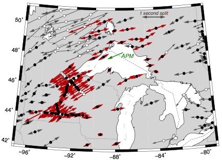
Figure: A map of SKS fabric
measurements in the SPREE study area and surroundings. Red arrows are
measurements from SPREE instruments; the arrow length is proportional to the
split time, while the arrow orientation is aligned with the fast direction.
Grey arrows are results from previous studies. Black circles indicate
measurements with split times of less than one second; white arrows indicate
larger split times. The green arrow indicates the current absolute plate motion
(APM) of the North American plate in the study area.
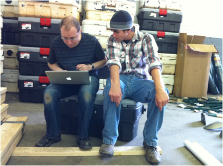
Photo: co-PI Andrew Frederiksen and field experiment co-manager Trevor
Bollmann squeezing a scientific discussion into preparatory activity for the
first SPREE station installations. Photo taken at a Minnesota warehouse
arranged by co-PI Justin Revenaugh.
References:
Ola, O., A. W. Frederiksen, T. Bollmann, S. van der Lee, F. Darbyshire,
E. Wolin, J. Revenaugh, C. Stein, S. Stein, and M. Wysession. "Anisotropic
zonation in the lithosphere of Central North America: Influence of a strong
cratonic lithosphere on the Mid-Continent Rift." Tectonophysics 683 (2016): 367-381.