Title: Igneous
rock layers above and below the continental crust of the Mid-continent Rift.
NSF award numbers: EAR-0952345 (2010-2014) and EAR-1148088 (2011-2015)
Collaborators
Hao Zhang1,
Suzan van der Lee1,
Emily Wolin1, Trevor A.
Bollmann1, Justin Revenaugh2, Douglas A. Wiens3, Andrew W. Frederiksen4, Fiona A. Darbyshire5, Ghassan I. Aleqabi3, Michael E. Wysession3, Seth Stein1, and Donna M. Jurdy1
1. Northwestern University
2. University of Minnesota
3. Washington University
4. University of Manitoba
5. University of Quebec at Montreal
Summary:
Seismic stations of the Superior Province Rifting Earthscope
Experiment (SPREE) recorded seismic waves from distant earthquakes for two and
a half years. SPREE stations were
installed in Minnesota, Wisconsin, and Ontario, along, across, and around a
prominent, one-billion-year-old structure related to the Mid-continent
Rift. The Mid-continent Rift is
distinguished by voluminous one-billion-year-old lava flows. Layer boundaries in the Mid-continent's
Rift's crust scattered some of the distant earthquakes' seismic wave energy in
ways that the SPREE stations could record perceptibly for more than one hundred
earthquakes. Our analysis of these
scattered waves reveals that the younger sedimentary rocks that cover the old
lava flows are up to 3 km thick but that the central lava flows are less deeply
buried than the flows' flanks. These differences in burial depth of the dense volcanic
rocks locally changes the Earth's acceleration of gravity by minute but
measurable amounts that constitute one of the most prominent "gravity
anomalies" in North America. The most striking revelation of our SPREE data analysis
is that deep beneath the Rift's central lava flows there is a second,
"underplated" layer of igneous (volcanic) rocks, at the bottom of the Rift's
continental crust. Along-Rift variations in the depth of this inferred
underplated material and other rift structures, such as the sedimentary rocks,
suggest that some central segments of the Mid-continent Rift were tectonically
pushed upwards after rifting, while other segments were not. This leads to an
estimated post-rift compression in a northwest-southeast direction.
Location tags:
Minnesota, Wisconsin, Ontario
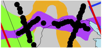
Figure 1: A rotated geological map (from Whitmeyer and Karlstrom) of a prominent
segment of the Mid-continent Rift (purple). The black dots are SPREE's seismic
station locations. The Superior Craton is in grey, the Penokean Terrain in
orange, the Yavapai Province in green, and the current Great Lakes in light
blue.
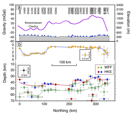
Figure 2: Along-rift layer-boundary structure inferred from scattered seismic
waves. The top frame (labeled a) shows the SPREE seismic stations (blue
triangles), but in cross-sectional view, along with station names, topography
(grey-filled), and the strength of the gravity anomaly (purple line). The
bottom frame is split into two different depth scales. Dashed lines are
inferred interpolations between imaged boundary depths, represented by dots.
The yellow dots represent the bottom of younger sedimentary rocks. The red, blue, and green dots represent
different estimates of the boundary between the crust and the mantle. This
boundary is normally a 40 km deep, single, sharp boundary in this area but this
frame shows that along the Mid-continent Rift, there is an intermediate zone
(between the red and green dashed lines) of underplated igneous material between
the continental crust and the mantle.

Photo: PI Suzan
van der Lee with field experiment co-manager Emily Wolin and field assistant
Simon Lloyd ready to dismantle a Wisconsin SPREE station.
References:
Zhang, H., et
al. (2016), Distinct crustal structure of the North American Midcontinent Rift
from P wave receiver functions, J. Geophys. Res. Solid Earth, 121,
doi:10.1002/2016JB013244.
Whitmeyer, S.
J., and K. E. Karlstrom (2007), Tectonic model for the Proterozoic growth of
North America, Geosphere, 3(4), 220–259.