Title A clearer look at a giant scar that underlies the American
Midwest
Award Number EAR- 0952154
(2010-2014)
Collaborators
Weisen Shen, Douglas A Wiens,
Ghassan Aleqabi, Michael
Wysession, Suzan van der Lee,
Hao Zhang, Seth Stein, Andrew Frederiksen, Fiona Darbyshire,
Emily Wolin and Trevor Bollmann
Project Highlights
Buried beneath the fertile flat farmland of the midwest, a
huge scar gives rise to the most prominent gravity and magnetic anomalies
within the old and stable core of the North America continent. The Midcontinent Rift (MCR) was the
location of an episode of extension between eastern and western North America,
and is now filled by a large volume of ~ 1.1 Ga old igneous rocks. Recent
deployments of the Earthscope/USArray and the Superior Province Rifting
Earthscope Experiment (SPREE) flexible array experiment enabled us to perform a
comprehensive seismic investigation of the crustal and uppermost mantle
structure in the vicinity of the MCR, including the part in the southern
Superior craton, and provide a better understanding of MCR geology. Receiver
function images show a complex structure at the depth of the typically simple,
sharp boundary between crust and mantle (see Shen et al., 2013, and Zhang et
al., 2016), perhaps representing a distinct layer of magmatic underplating
beneath the rift. Surface wave tomography reveals the spatial distribution of
this anomalous crustal underplating structure, extending beneath the Lake Superior
(Fig. 2). By incorporating these receiver function and surface wave data, a
refined seismic model for the MCR area is being constructed. Combining these complementary
seismic observables improves our shear velocity structure of the crust and
mantle. A joint Bayesian Monte-Carlo inversion finds a distinct layer with
shear wave speed between 4.0 and 4.4 km/sec associated with the Moho beneath
the MCR, further confirming crustal underplating associated with rifting.
Location Keywords: Midwest, Central US, Lake Superior
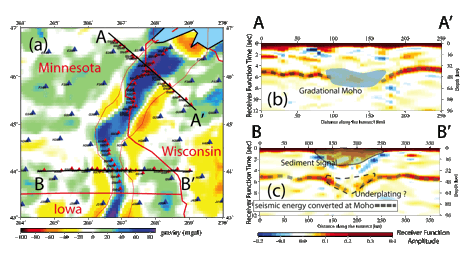
Figure 1. (a) SPREE array stations (red
triangles) run along and across the gravity anomaly (blue) that is the rift.
These stations are much closer together than the USArray ones (blue triangles).
Images of the receiver function show a gradient rather than sharp Moho beneath
the rift (b), which may be due to magma trapped at the Moho or in the lowermost
crust/uppermost mantle (c).
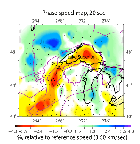
Figure 2. Phase speed map for a type of
surface wave called a Rayleigh wave. The speed mapped is for a Rayleigh wave
with a periodicity of 20 s (a wavelength of 72 km). This wave's speed is
sensitive to the stiffness of the lower crust and the density of the upper
crust. The map shows that the buried layers of dense volcanic rock have an
impact on this Rayleigh wave's speed and that these layers extend along the
entire rift, to Lake Superior.
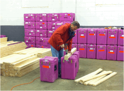
Photo: co-PI Doug Wiens drilling holes for solar-panel frames for SPREE stations
References:
Shen, Weisen, Michael H. Ritzwoller, and Vera Schulte‐Pelkum. "Crustal and uppermost mantle structure in the central US encompassing the Midcontinent Rift." Journal of Geophysical Research: Solid Earth 118, no. 8 (2013): 4325-4344.
Zhang, H., et al. (2016), Distinct crustal structure of the North American Midcontinent Rift from P wave receiver functions, J. Geophys. Res. Solid Earth, 121, doi:10.1002/2016JB013244.